


Wynd Cottage, Whitby Historic Building Assessment
This is the report of Historical Building Assesment we had carried out in 2023. The Assement was carried out by Dr James Wright FSA of Triskele Heritage. We can highly recomend the services he offers. After many years trying to figure out when Wynd cottage was built and modified we decided to call in the best expert we could find.
The full PDF of the Report is available to download here 
For ease of navigation I've split the report over three web pages and put the photos, illustrations and maps etc in with the text.
1. Introduction (this page)
Summary
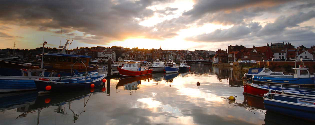
Wynd Cottage is located on the east side of Cliff Street, Whitby, North Yorkshire. The National Grid Reference for the site is NZ 89769 11216. Triskele Heritage were commissioned by the landowners to make a historic building assessment of the property for research purposes only. The fieldwork took place in May 2023.
The primary core of the building is probably seventeenth century in date and was substantially remodelled during the later eighteenth century. The west and south elevations of the building are constructed from dressed ashlar stone. The east elevation is of rendered brick and stone. The north elevation is of brick. The property was originally accessed from the street via an alleyway which loops around the north and east side. A front door has been inserted at the south end of the street frontage. It grants access to a stair hall with a dining room and kitchen beyond. Previously the ground floor was a single space housebody with an inglenook fireplace and a timber firehood. This was remodelled, probably during the eighteenth century to create a handmade brick chimney stack against the south elevation and a close-boarded kitchen in the north-west corner.
The first-floor level was lowered slightly during the eighteenth century and a staircase replaced an earlier notched ladder. This floor was originally a bedchamber and store. It was remodelled in the eighteenth century to create close-boarded spaces which now include a living room, bathroom, and bedroom. The second floor is also probably a product of the eighteenth century and incorporates a landing and two bedrooms within the attic of the house.
The building contains a relict principal roof truss against the north elevation. This has evidence for its origins in the cruck tradition as it includes spurs and a Type C apex yoke. The roof was heightened and rebuilt with two rows of purlins and dormer gables to the east and west pitch.
Wynd Cottage contains four examples of reused futtocks from a carvel-built large boat or small ship. These timbers were used as two lintels in the alleyway, a bracket in the fireplace and as a collar in the relict roof truss.
Contents
Introduction
Location
Outline Description
Fieldwork and Research Methodology
Organisation of the Report
Historic Background
Archaeological Description
Exterior Elevations of the Property
Interior of Wynd Cottage
Ground Floor
First Floor
Second Floor
Roof Structure
Timbers Reused from Marine Vessels
Conclusions
References
Bibliography
Website
Author Credentials
Acknowledgements
Statement of Indemnity
Introduction
Location
Wynd Cottage is situated on the east side of Cliff Street to the north of Pier Lane in Whitby, North Yorkshire (Figure 1). The National Grid Reference for the site is NZ 89769 11216. The property lies on the western shoulder of the valley of the tidal River Esk as it passes through the harbour of Whitby.
Outline Description
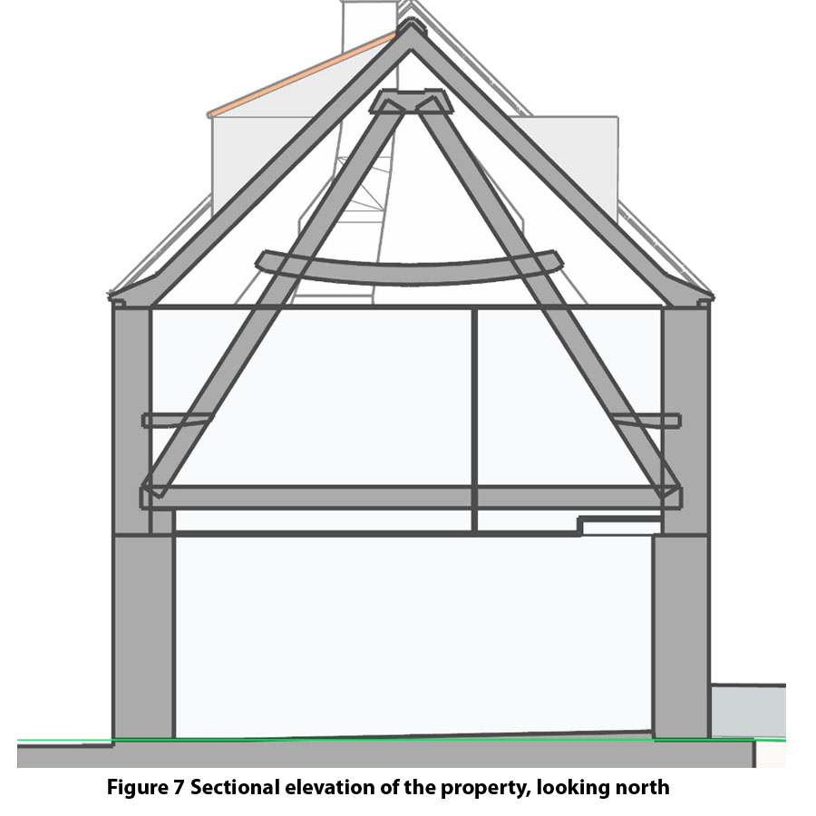
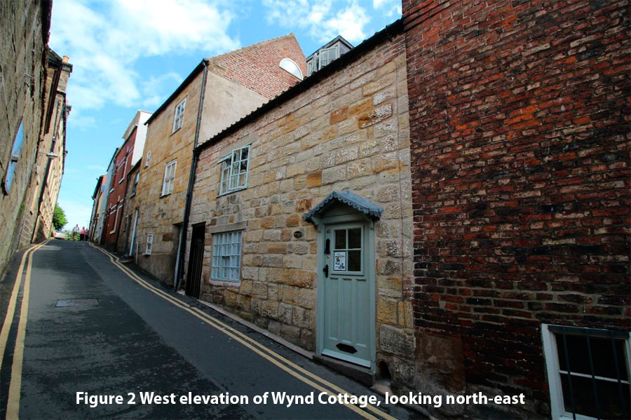 Wynd Cottage is an approximately square property, measuring 6.4 metres by 6.64 metres, which fronts on to the eastern side of Cliff Street (Figure 2). The building stands on terraced and sloping ground which overlooks Whitby Harbour to the east (Figure 3 and Figure 4). The property is constructed from dressed and coursed ashlar stone, with later brick inserts and a pantile roof. It is two storeys in height with an attic (Figure 5, Figure 6, Figure 7 and Figure 8). There is a structurally separate wash house to the east. The ground floor is accessed via a door in the west elevation and to the east from an alleyway which loops around the north side of the building from Cliff Street. The ground storey contains a dining room, kitchen, and stair hall. The stairs rise to the east and grant access to the living room, bathroom, and first floor bedroom. A lobby leads to the stair to the second floor, which contains a corridor and two further bedrooms. A relict roof truss stands against the north elevation and elements of it can be seen at both first and second floor levels.


Fieldwork and Research Methodology
The building is currently in the ownership of Andy and Wendy Bell who have commissioned this piece of research into their property. The project sought to assess, date, and phase the structure of the building. The work was informed by reference to the standard guidance and manuals on buildings archaeology fieldwork practice (Historic England 2016). However, the scope of the works did not strictly conform to the Level 1, 2, 3, or 4 surveys as outlined by Historic England. Instead, the project represents a light-touch assessment as a piece of pure research.
James Wright of Triskele Heritage attended site in May 2023. Schematic drawings provided by the landowners (Figure 5, Figure 6, Figure 7 and Figure 8) were annotated. The property was photographed in general and in detail using a Canon EOS 1200D camera. A basic level of historic background research was carried out and included reference to historic mapping and some published sources.
The site archive comprises two drawings on A4 paper and 77 digital photographs of the building (of which 28 are reproduced in this report). The archive will be retained by Triskele Heritage.
Organisation of the Report
After the Introduction, the text will incorporate three distinct sections: Historic Background, Archaeological Description and Conclusions. The Historic Background will deliver the results of the basic historic research. It will serve to outline the known history of the building based on historic maps and published sources. The Archaeological Description is based on the fieldwork and deals with the material culture of the architecture. It will describe the structure, fabric, and features. The building will be broken down into its constituent elements. The Conclusions will draw together the report.
Throughout the report mention will be made to the third-party opinions of other authors. Such material will always be acknowledged via Harvard References (author date, page number; e.g., Hall 2005, 165) which will link to the References section. Where websites have been consulted the link and date that the site was accessed is given. The report is illustrated with photographs, drawings, and scanned archival material. Figure numbers will be referred to throughout the text and the illustrations are all grouped at the rear of the document. Reference should be made to the schematic phased ground and first floor plans (Figure 5 and Figure 6) as well as the sectional elevation drawings (Figure 7 and Figure 8) for spatial data. All four drawings were produced by the landowner and are schematic only; a second-floor plan was not provided. Unless otherwise credited, all photographs in the report were taken by James Wright of Triskele Heritage.
Historic Background
Wynd Cottage is an unlisted structure which is does not appear within the standard texts or repositories of information on historic buildings; for example: Pevsner 2002, 387-400; the National Heritage List for England (NHLE); or the North Yorkshire County Council Historic Environment Record (NYCCHER).
The Whitby historian, the Reverend George Young thought that Cliff Street, upon which Wynd Cottage lies, was known as Scate Lane as early as 1614 (Young 124, 156). However, seventy years later, another cleric, the Reverend J. C. Atkinson, noted that Cliff Lane may formerly have been called Russell Lane. He cited his source as the Minister’s Accounts of 1540, contained within the Whitby Abbey Cartulary.
 Atkinson’s reading of the document posits that the street lay within ground, known as Russell lands, that were likely bounded by “Haggersgate to the east, Flowergate on the south, and Skinner Street on the west, and towards the sea cliff on the other side” (Atkinson 1894 190). Russell Lane had thirteen cottages at this time which were rented for sums spanning from 3 shillings up to 12 shillings (Atkinson 1894, 191). It is not clear if Wynd Cottage was one of these mid-sixteenth century dwellings. Atkinson drew a speculative map of Whitby as it may have appeared in 1540 and he shows the thirteen cottages grouped at the south end of Russell Lane, with the site of Wynd Cottage depicted as empty (Figure 9).
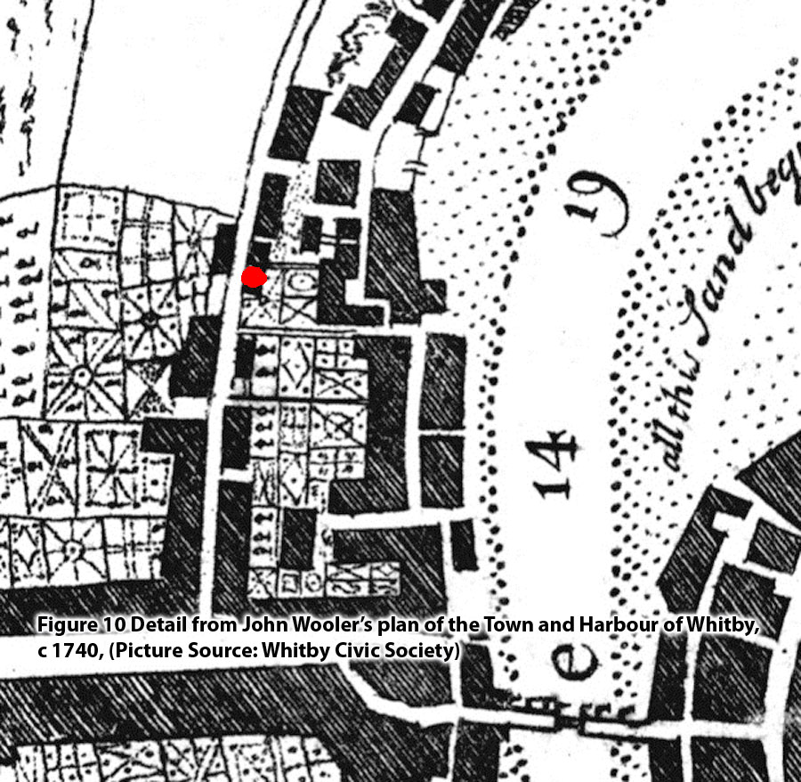
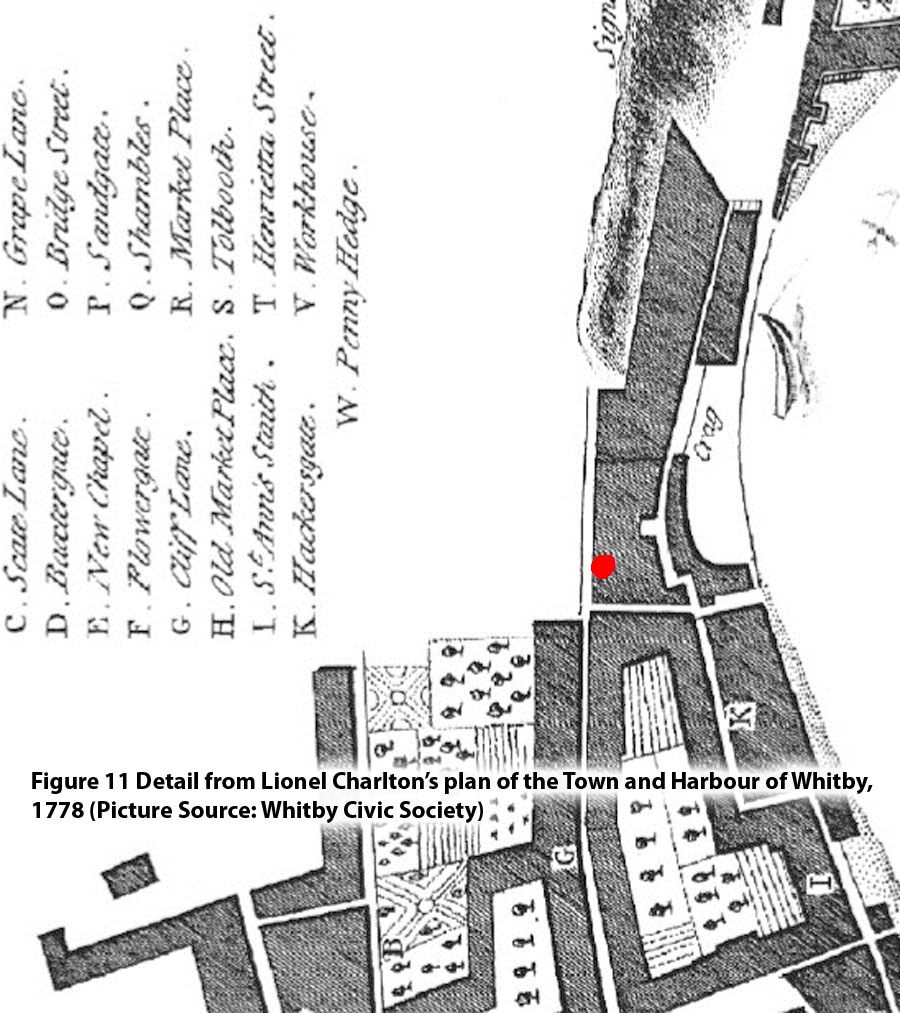
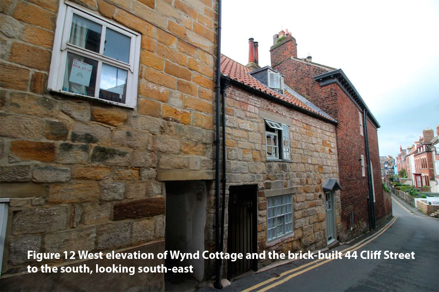
The earliest map to show development on the site is John Wooler’s plan of c 1740 (Figure 10). It indicates that structures stood on the approximate the location of Wynd Cottage, with vacant ground immediately to the south. The empty plot was eventually filled with 44 Cliff Street by the time of Lionel Charlton’s map of 1778 (Figure 11 and Figure 12). John Wood’s plan of 1828 broadly confirms this arrangement (Figure 13).
The first depiction to show a clear property boundary comes from a map of 1845 which depicts a roughly square building with a narrow yard to the east, as well as a water pump and a set of steps leading to a terrace (Figure 14). This assembly is confirmed on the first Ordnance Survey map, made in 1891 (Figure 15), and on a plan drawn up during the 1920s which clearly uses the latter as its basis (Figure 16). Between the 1920s plan and the production of the Ordnance Survey map of 1938 (Figure 17) the wash house was constructed to the east of Wynd Cottage.
This brief assessment of the historic background has demonstrated that Cliff Lane may have been in existence by the sixteenth or seventeenth century and that a property existed on the site of Wynd Cottage by at least c 1740.


1. Introduction (this page)
James Wright has also publish this report on his website "Wynd Cottage, Cliff Street, Whitby".